Indexing your document with Geolocation information
OpenSearchServer supports geolocation requests. Once coordinates (longitude and latitude) have been embedded within indexed documents, it is possible to filter these based on whether they lie within a defined geographic rectangle.
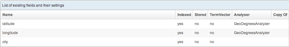
Preparing the schema
First, provide the latitude and the longitude of the document.
The schema should include two fields to hold this information:
- latitude (indexed)
- longitude (indexed)
Choose the analyzer corresponding to the coordinate system:
- GeoRadianAnalyzer
- GeoDegreesAnalyzer
Indexing the data
The coordinates (latitude and longitude) should be expressed in decimal format. Examples:
- For Degrees: -52.090904
- For Radians: -0.675757575575
Using the API, just add the two fields to your JSON document
The JSON indexing API is documented on our API wiki.
[
{
"lang": "ENGLISH",
"fields": [
{ "name": "city", "value": "New-York" },
{ "name": "latitude", "value": 40.7142700 },
{ "name": "longitude", "value": -74.0059700 }
]
},
{
"lang": "FRENCH",
"fields": [
{ "name": "city", "value": "Paris" },
{ "name": "latitude", "value": 48.8534100 },
{ "name": "longitude", "value": 2.3488000 }
]
},
{
"lang": "GERMAN",
"fields": [
{ "name": "city", "value": "Berlin" },
{ "name": "latitude", "value": 52.5243700 },
{ "name": "longitude", "value": 13.4105300 }
]
}
]
Querying
Example: let's find a city located within 10 kilometers of a given point (the "central position").
The latitudeField and longitudeField are mapped to the fields of the schema.
The "geo" part contains the central position.
The "GeoFilter" applies a geographical filter following the provided parameters.
Just make a geolocated search using the Search(Field) API described on our API wiki:
{
"start": 0,
"rows": 10,
"geo": {
"latitudeField": "latitude",
"longitudeField": "longitude",
"latitude": 48.85341,
"longitude": 2.3488,
"coordUnit": "DEGREES"
},
"emptyReturnsAll": true,
"filters": [
{
"type": "GeoFilter",
"shape": "SQUARED",
"negative": false,
"unit": "KILOMETERS",
"distance": 10
}
],
"returnedFields": [ "city", "latitude", "longitude" ]
}
Document returned
Here are the results.
{
"successful": true,
"documents": [
{
"pos": 0,
"score": 1,
"collapseCount": 0,
"fields": [
{
"fieldName": "city",
"values": [
"Paris"
]
},
{
"fieldName": "latitude",
"values": [
"P0.8526529"
]
},
{
"fieldName": "longitude",
"values": [
"P0.0409943"
]
}
]
}
],
"facets": [],
"query": "*:*",
"rows": 10,
"start": 0,
"numFound": 1,
"time": 126,
"collapsedDocCount": 0,
"maxScore": 1
}
Adding distances to search results
To list the distance between the searched coordinates and the returned documents, a "scorings" array is needed in the query:
{
"start": 0,
"rows": 10,
"geo": {
"latitudeField": "latitude",
"longitudeField": "longitude",
"latitude": 48.85341,
"longitude": 2.3488,
"coordUnit": "DEGREES"
},
"emptyReturnsAll": true,
"filters": [
{
"type": "GeoFilter",
"shape": "SQUARED",
"negative": false,
"unit": "KILOMETERS",
"distance": 10
}
],
"returnedFields": [ "city", "latitude", "longitude" ],
"scorings": [
{
"ascending": false,
"weight": 1,
"type": "DISTANCE"
}
]
}
Here are the results:
{
"successful": true,
"documents": [
{
"pos": 0,
"score": 1,
"distance": 0.00033325536,
"collapseCount": 0,
"fields": [
{
"fieldName": "city",
"values": [
"Paris"
]
},
{
"fieldName": "latitude",
"values": [
"P0.8526529"
]
},
{
"fieldName": "longitude",
"values": [
"P0.0409943"
]
}
]
}
],
"facets": [],
"query": "*:*",
"rows": 10,
"start": 0,
"numFound": 1,
"time": 0,
"collapsedDocCount": 0,
"maxScore": 0
}